if(
regexp_substr(description, 'img src="!?.*img src="(.*)"') = '',
regexp_substr(description, 'img src="(.*)"'),
regexp_substr(description, 'img src="!?.*img src="(.*)"')
)9 Sept 2022
QGIS REGEX Expression to Find Last Vaue of an XML/Html Image Source of the Description Field of a KML File
Labels:
expression
,
KML
,
QGIS
,
Regex


18 Oct 2016
Collect GPX-Files from Subdirectories and Convert to Single KML File
Reference: https://cran.r-project.org/web/packages/sp/vignettes/intro_sp.pdf
library(sp)
library(rgdal)

# here, m ygpx files reside in subdirectories..
setwd("D:/WEB/gardaweb")

files <- dir(pattern="*.gpx$", recursive = T, include.dirs = T)

# extract spatial lines
spl <- lapply(files, function(x) {readOGR(x, "tracks")@lines[[1]]} )
str(spl)

# apply ID to ID slot for latter merge with attribute data
for(i in 1:length(spl)) {slot(spl[[i]], "ID") <- as.character(i)}
tracksSL <- SpatialLines(spl, proj4string = CRS("+proj=longlat +datum=WGS84"))

# view data
summary(tracksSL)
plot(tracksSL)

# make dataframe for merging with spatial data
names <- sub("[.]gpx$", "", basename(files))
df <- data.frame(names = names, row.names = sapply(slot(tracksSL, "lines"), function(x) slot(x, "ID")))

# spatial dataframe
tracksSLDF <- SpatialLinesDataFrame(tracksSL, data = df)

# write ressult to KML
writeOGR(tracksSLDF, dsn="tracks_collection.kml", layer= "Wolfi_Garda_Tracks", driver="KML", dataset_options=c("NameField=names"))
Labels:
directories
,
files
,
GPX
,
KML
5 Feb 2015
Usecase for KML-Parsing: Make New KML-File from File-Collection
In this usecase I had collected several KMLs from the internet but wanted to strip them down for only the relevant parts (the Linestrings inside the Placemark-nodes) and put them all inside one final File. In my script I create a new KML file and populate a folder-node inside it with Linestrings from the collection of KML-files which all reside in the same source directory. For this one needs to parse each file and grab the appropiate nodes and add them to the target kml file. In addition I alter some oroginal values, i.e. I use the file names of the single KML-files as Placemark names inside the new KML-file.
Here is the final file as seen after opening in Google Earth:

Here is the final file as seen after opening in Google Earth:

library(XML)

# new kml file... needs to be well-formed
z <-
  '<kml xmlns="http://www.opengis.net/kml/2.2">
      <Document>
         <Folder>
            <name>ROUTES</name>
         </Folder>
      </Document>
    </kml>'
new_xmlDoc <- xmlInternalTreeParse(z, useInternalNodes = TRUE)

# important add all namespace definitions...
ns <- c(gx="http://www.google.com/kml/ext/2.2",
        kml="http://www.opengis.net/kml/2.2",
        atom="http://www.w3.org/2005/Atom")
ensureNamespace(new_xmlDoc, ns)

# get the root off the new file for latter processing
new_root <- xmlRoot(new_xmlDoc)

# loop over files from folder
# and insert Placemark content of each file as children nodes into
# the new file

setwd("C:/Users/Kay/Google Drive/SKI-BIKE/Gastein")
files <- dir(pattern="bergfex*")

for (f in files) {

   # get placemark node of each file
   doc <- xmlInternalTreeParse(f, useInternalNodes = TRUE)
   root <- xmlRoot(doc)
   plcm_node <- root[["Document"]][["Folder"]][["Folder"]][["Placemark"]]

   # insert file name as Placemark name
   xmlValue(plcm_node[["name"]]) <- sub('bergfextour_(.*)[.]kml', '\\1', f)

   # add placemark node to new doc
   addChildren(new_root[["Document"]][["Folder"]], plcm_node)

}

# save it...
saveXML(new_xmlDoc, "collapsed_ROUTES.kml")
Labels:
GIS
,
KML
,
XML-Package
26 Sept 2014
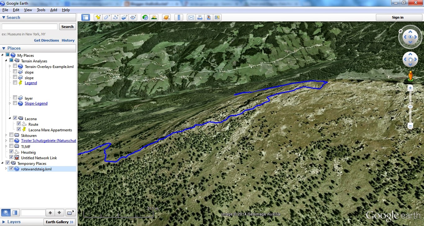
Make a KML-File from an OpenStreetMap Trail
Ever wished to use a trail on OSM on your GPS or smartphone? With this neat little R-Script this can easily be done. You'll just need to search OpenStreetMap for the ID of the trail (way), put this as argument to osmar::get_osm, convert to KML and you're good to go!


# get OSM data
library(osmar)
library(maptools)

rotewandsteig <- get_osm(way(166274005), full = T)
sp_rotewandsteig <- as_sp(rotewandsteig, what = "lines")

# convert to KML
kmlLine(sp_rotewandsteig@lines[[1]], kmlfile = "rotewandsteig.kml",
        lwd = 3, col = "blue", name = "Rotewandsteig")

# view it
shell.exec("rotewandsteig.kml")
Labels:
GIS
,
KML
,
OpenStreetMap
,
osmar
,
R
4 May 2014
R GIS: Function to Reverse KML Paths
This is a function I wrote up for reversing KML-paths. The paths within a KML can be partially matched by their name-tags
## name:          ReverseKmlPath
## use:           Reverse KML-pathsby matching their Name tags
## arguments:     PATH_TO_DOC, the path to the KML-file
##                NAME, the value of the name tag, function uses partial matching!
##                'Trail_xyz' will be matched by 'rail'
## requirements:  KML-structure with Placemarks containing a  and a  tag
## author:        Kay Cichini
## date:          01-05-2014
## license:       CC-BY-NC-SA

ReverseKmlPath <- function(PATH_TO_DOC, NAMES) {

    require(XML)

    doc <- xmlInternalTreeParse(PATH_TO_DOC)

    if (xmlNamespaceDefinitions(doc)[[1]]$uri == "http://www.opengis.net/kml/2.2") {
        namespaces <- c(kml = "http://www.opengis.net/kml/2.2")
        flag <- 1
    } else {
        if (xmlNamespaceDefinitions(doc)[[1]]$uri == "http://earth.google.com/kml/2.0") {
                namespaces <- c(kml0 = "http://earth.google.com/kml/2.0")
                flag <- 0
            } else {
                stop ("Stopped!: Check namespace issue..")
            }
    }


    for (NAME in NAMES) {

        if (flag) {
              query <- paste0("//kml:Placemark[contains(kml:name,'", sprintf("%s", NAME), "'", ")]//kml:coordinates")
          } else {
              query <- paste0("//kml0:Placemark[contains(kml0:name,'", sprintf("%s", NAME), "'", ")]//kml0:coordinates")
          }

        coords <- tryCatch(getNodeSet(doc, query, namespaces),
                           error = function(e) message(paste("\nError: *", NAME, "* was NOT successfully matched\n")))

        for (i in length(coords)) {

            #grab coordinates from node and reverse order
            rev_coord_vector <- rev(unlist(strsplit(gsub("\\t|\\n", "", xmlValue(coords[[i]])), "\\s")))
            rev_coord_string <- paste(rev_coord_vector, collapse = " ")

            # re-insert reversed line-string:
            xmlValue(coords[[i]]) <- rev_coord_string

            # message
            if (flag) {
                  query <- paste0("//kml:Placemark[contains(kml:name,'", sprintf("%s", NAME), "'", ")]//kml:name")
              } else {
                  query <- paste0("//kml0:Placemark[contains(kml0:name,'", sprintf("%s", NAME), "'", ")]//kml0:name")
            }
            match <- xmlValue(getNodeSet(doc, query, namespaces)[[i]])
            message(paste0("matched name: ", match, "\n..."))

        }
    }

    # save:
    message("Reversed paths saved to:")
    saveXML(doc, paste0(dirname(PATH_TO_DOC), "/reversed_", basename(PATH_TO_DOC)),
            prefix = newXMLCommentNode("This file was created with the R-package XML::saveXML, see: "))
}

## not run:
tf <- tempfile(fileext = ".kml")
download.file("http://dev.openlayers.org/releases/OpenLayers-2.13.1/examples/kml/lines.kml", tf, mode = "wb")
ReverseKmlPath( PATH_TO_DOC = tf, NAMES = c("Absolute", "Relative") )

shell.exec(tf)
shell.exec(paste0(dirname(tf), "/reversed_", basename(tf)))
3 May 2014
R GIS: Generalizer for KML Paths
I'm posting a recent project's spin-off, which is a custom line-generalizer which I used for huge KML-paths. Anyone with a less clumpsy approach?
## line generalizing function: takes two vectors of with x/ycoords
## and return ids of x/y elements which distance to its next element
## is shorter than the average distance between consecutive vertices
## multiplied by 'fac'
check_dist <- function(x, y, fac) {
    dm <- as.matrix(dist(cbind(x, y)))

    ## supradiagonal holds distance from 1st to 2nd, 2nd to 3rd, etc. element
    d <- diag(dm[-1, -ncol(dm)])
    mean_dist <- mean(d)
    keep <- logical()

    ## allways keep first..
    keep[1] <- T
    for (i in 1:(length(x) - 2)) {
        keep[i + 1] <- (d[i] > mean_dist * fac)
        message(paste0("Distance from item ", i, " to item ", i + 1, " is: ", d[i]))
    }
    message(paste0("Treshold is: ", mean_dist * fac))
    cat("--\n")
    ## .. and always keep last
    keep[length(x)] <- T
    return(keep)
}

## Testing function check_dist:
x <- rnorm(5)
y <- rnorm(5)
(keep <- check_dist(x, y, 1.2))

plot(x, y)
lines(x[keep], y[keep], lwd = 4, col = "green")
lines(x, y, lwd = 1, col = "red")
text(x, y + 0.1, labels = c(1:length(x)))


## exclude vertices by generalization rule. coordinate-nodes with low number of vertices,
## segments with less than 'min_for_gen' vertices will not be simplified, in any case coordinates will be
## rounded to 5-th decimal place

generalize_kml_contour_node <- function(node, min_for_gen, fac) {

    require(XML)

    LineString <- xmlValue(node, trim = T)

    LineStrSplit <- strsplit(unlist(strsplit(LineString, "\\s")), ",")

    # filter out empty LineStrings which result from strsplit on '\\s'
    LineStrSplit <- LineStrSplit[sapply(LineStrSplit, length) > 0]

    # all 3 values are required, in case of error see for missing z-values:
    x <- round(as.numeric(sapply(LineStrSplit, "[[", 1, simplify = T)), 5)
    y <- round(as.numeric(sapply(LineStrSplit, "[[", 2, simplify = T)), 5)
    z <- round(as.numeric(sapply(LineStrSplit, "[[", 3, simplify = T)), 5)

    # for lines longer than 'min_for_gen' vertices, generalize LineStrings
    if (length(x) >= min_for_gen) {
        keep <- check_dist(x, y, fac)
        x <- x[keep]
        y <- y[keep]
        z <- z[keep]
        xmlValue(node) <- paste(paste(x, y, z, sep = ","), collapse = " ")

        # for all other cases, insert rounded values
    } else {
        xmlValue(node) <- paste(paste(x, y, z, sep = ","), collapse = " ")
    }
}

## mind to use the appropiate namespace definition: alternatively use:
## c(kml ='http://opengis.net/kml/2.2')
kml_generalize <- function(kml_file, min_for_gen, fac) {
    doc <- xmlInternalTreeParse(kml_file)
    nodes <- getNodeSet(doc, "//kml:LineString//kml:coordinates", c(kml = "http://earth.google.com/kml/2.0"))
    mapply(generalize_kml_contour_node, nodes, min_for_gen, fac)
    saveXML(doc, paste0(dirname(kml_file), "/simpl_", basename(kml_file)))
}

## get KML-files and generalize them
kml_file <- tempfile(fileext = ".kml")
download.file("http://dev.openlayers.org/releases/OpenLayers-2.13.1/examples/kml/lines.kml",
              kml_file, mode = "wb")
kml_generalize(kml_file, 5, 0.9)
shell.exec(kml_file)
shell.exec(paste0(dirname(kml_file), "/simpl_", basename(kml_file)))22 Dec 2012
Convert OpenStreetMap Objects to KML with R
A quick geo-tip:
With the osmar and maptools package you can easily pull an OpenStreetMap object and convert it to KML, like below (thanks to adibender helping out on SO). I found the relation ID by googling for it (www.google.at/search?q=openstreetmap+relation+innsbruck).
With the osmar and maptools package you can easily pull an OpenStreetMap object and convert it to KML, like below (thanks to adibender helping out on SO). I found the relation ID by googling for it (www.google.at/search?q=openstreetmap+relation+innsbruck).
# get OSM data
library(osmar)
library(maptools)

innsbruck <- get_osm(relation(113642), full = T)
sp_innsbruck <- as_sp(innsbruck, what = "lines")

# convert to KML
for( i in seq_along(sp_innsbruck) ) {
      kmlLine(sp_innsbruck@lines[[i]], kmlfile = "innsbruck.kml",
               lwd = 3, col = "blue", name = "Innsbruck")
      }

shell.exec("innsbruck.kml")
Labels:
Google Earth
,
KML
,
maptools
,
osmar
,
R
Subscribe to:
Posts
(
Atom
)